News
Multi-discipline surveys for overhead power lines
The inspection, repair and maintenance of power transmission infrastructure is an ongoing responsibility for power companies. With extensive networks, legacy equipment and remote locations, surveying overhead power lines and the pylons or poles that carry them is an expensive and time-consuming business.
So, companies are looking for state-of-the-art support that delivers safe inspection – without having to send lone workers to remote areas, or manage the health and safety issues around climbing infrastructure.
What do power companies need?
- Detailed surveys that cover all power infrastructure
- Accurate data, collected safely and quickly
- Experienced analysis that prioritises repair issues
- Imagery and modelling that speeds up repair work and improves efficiency
- Full scope of surveys to manage ground-based issues
- Limited, if any, disruption to power supplies
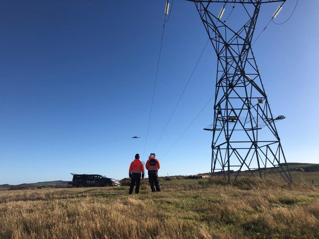
Using unmanned aerial systems (UAS) equipped with the latest imaging technology and working alongside more traditional survey methods allows power companies to gather higher quality data faster, more safely and more efficiently than old inspection approaches.
Case example: Highland OHL
We have been working with a number of OHL Transmission companies for several years, as part of their asset management team. Our teams take a section of the power network and use our UASs to collect a wide range of data. That data is then uploaded to our dedicated portal, TexZone, which has been customised to each transmission customer.
Then, our in-house engineers analyse all the images, covering a checklist of 67 different items. We generate a spreadsheet matrix that shows the issues and their severity, so that the client has everything they need to create a maintenance programme that’s both cost and time efficient. Access to the portal is shared across the clients organisation, and any nominated suppliers so that everyone can interrogate, interact and interpret the data quickly and easily.
Using our services, our clients have a targeted, dedicated and efficient maintenance programme. Using this reliable approach and dedicated teams TEXO have surveyed increasingly larger numbers of client assets month on month including hundreds of kilometres of UAS Lidar AND Photogrammetry surveys
Safety-critical piloting
Of course, flying UASs around power cables is a potentially risky business. So pilots need to be fully trained and highly competent and use the right equipment. Industrial grade UASs reduce the risk of electromagnetic interference and a host of other environmental factors. The latest imaging equipment helps us to capture fine details without needing to get too close to the infrastructure and paired with survey grade LiDAR systems capable of astonishing detail and accuracy at ranges past well past the hundreds of meters our team can get the required information at distance
It’s important to make sure that the team managing a UAS inspection or survey has the flying experience, the survey knowledge and the flexibility to plan an ongoing programme of inspection. Experienced pilots, for example, can carry out a bar-by-bar assessment, where every bar on the tower is imaged and assessed. It’s surveying on a precise basis.
Engaging multi-disciplinary services
A holistic survey programme uses more than UASs to achieve a full picture of the current state of an asset. So we bring in a range of other survey techniques that add to the useful data and allow clients to make informed decisions. These include LiDAR surveys to inspect the ground around pylons or substations, for example, showing hidden vegetation and general topography so that teams can plan confidently. And for common accidents like tractor strikes on pylons, the damage can be scanned, the data turned into precise design drawings and a decision made as to whether the pylon is still structurally sound. Our dedicated utility teams even aid our clients to map their assets beneath the ground surface to help them prevent incidents of cable strike or even confirming planned routes have sufficient space in the ground to go ahead. Paired with the highly detailed above ground picture from our UAS and survey teams enables a much clearer picture to be developed.
What are the benefits of state-of-the-art surveys?
Companies of all types, but particularly utility companies where infrastructure is often older, in remote locations and difficult or dangerous to access, need to maintain assets in the present and be able to plan for the future.
- Using professional, multi-offering survey support delivers a range of benefits:
- Highly accurate data that informs better decisions and planning
- Reduced health and safety risks
- Faster data collection and processing
- Easy to survey infrastructure in remote or dangerous areas
- Precise images and models that speed up diagnosis and action
Of course, it’s not just overhead lines that benefit from this type of survey. Underground cables are also expensive to maintain and repair, and it can be a time-consuming job to find out where cables are visible, damaged or causing other problems. A good UAS survey mapping programme can cover around 10km per day, taking detailed images that pinpoint areas of concern and allow repairs to be made quickly and cost-effectively.
Choosing UAV survey suppliers
Businesses that want to improve their asset inspection and maintenance programmes are already moving to utilise UAS-based surveys as part of their toolbox of techniques. It’s important, however, to make sure you work with professional teams who can not just pilot UASs safely and collect the right data at the right time, but know how to manage that data to give you the best results.
That’s why you should look for an integrated service – where UAS survey is enhanced by other survey methods and where the data is translated into useful models, reports and data that speed up your processes and give you the exact information you need when you need it. Having independent access to the data is critical, as it allows you to perform your own analysis depending on your priorities.
At TEXO, we provide highly skilled survey teams and our specialist portal holds all your data securely on the cloud, giving you and your wider teams access to all the information you need. And, as part of a wider multi-disciplinary group, we also have the experience and expertise to help you with your asset repair programme. Our mission is to deliver the best service and the best results every time.